
macomb north branch greenway plan
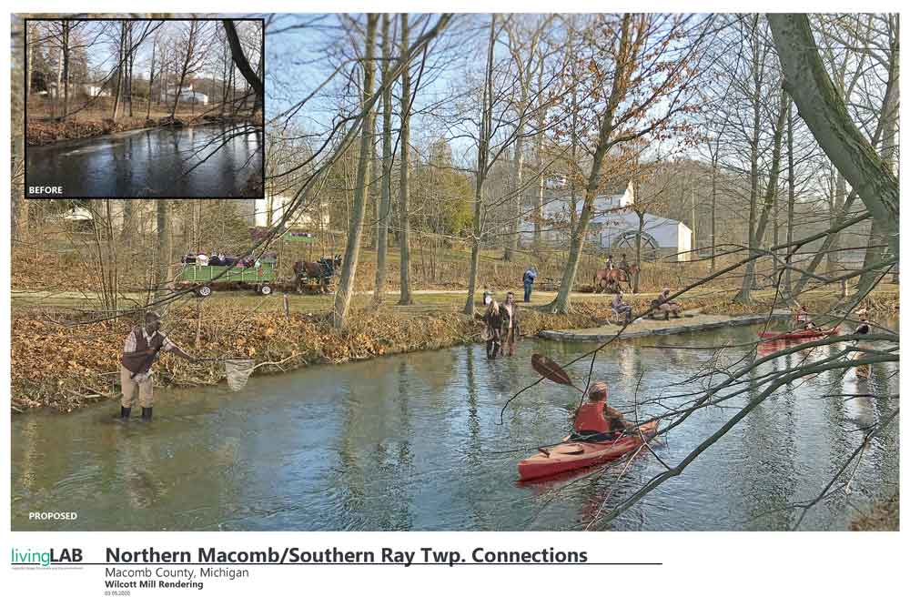
Macomb County Planning and Economic Development was awarded a grant from SEMCOG in 2019 to develop a vision for a Greenway along the North Branch of the Clinton River. The primary long-term goals of the project were to 1) reduce the impact of future flooding within the North Branch of the Clinton River, 2) to work strategically to protect the riparian corridor, and 3) establish a multi-modal linear recreational corridor along, or near, the North Branch of the Clinton River from Clinton Township’s Budd Park to the Macomb Orchard Trail. livingLAB assisted the County and a Steering Committee in developing the Greenway Plan and associated graphics that will assist in communicating the vision for a protected and connected riparian corridor along the North Branch.
The proposed North Branch Greenway follows the North Branch of the Clinton River from the confluence with the Main Branch of the Clinton River in Clinton Township, north through Macomb, Ray and Armada Townships and the East Branch Coon Creek in Lenox Township. The study also identifies potential trail routes and conservation strategies along the publicly- and privately-owned properties. The proposed North Branch Greenway works to not only protect and conserve the riparian corridor, but also envisions a network of trails that would traverse the center of the County and connect the Freedom Trail in the south to the Macomb Orchard Trail in the north. The plan serves as a guide and tool for local, county and regional agencies to assist in policy development, master plan and ordinance development, land acquisition, and creation and promotion of recreation opportunities.
- Date : November 2, 2020